
A Selection of Maps from the Research Library
“The Map is not the territory” observed scientist and philosopher Alfred Korzybski, referring to our perceptions of the world versus the world we actually live in.
With the passage of time, however, inevitable changes in the land—erosion, landslides, upheaval, as well as changes to the landscape brought about by humankind—make maps one of the most important sources of information about what was at a particular place and time. Maps are often some of the very best “windows” to what no longer remains, or remains in ways not easily recognizable.
Take, for instance, the angled line of the Mission San Buenaventura orchard wall as shown in the U.S. Coast Survey of 1855. The adobe walls of the orchard are now long gone—only a portion of the rock base survives underground. But the line of the north wall, which followed ancient foot paths, can still be seen on Main Street as it angles towards Ventura Avenue. Likewise, the small lots that were established for some of the Mission faithful inside the south orchard wall—as shown on the E.T. Hare map of San Buenaventura (1888)—can still be seen in the north facing lots of houses and businesses on Thompson Boulevard between Junipero and Figueroa Streets. Both are patterns from earlier times.
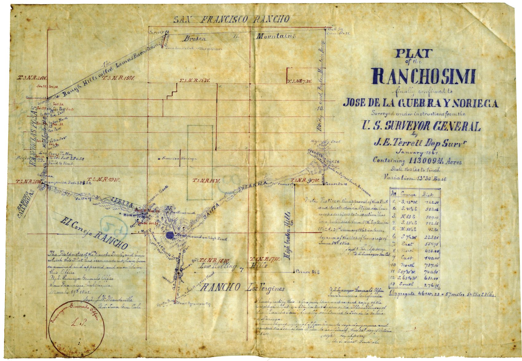
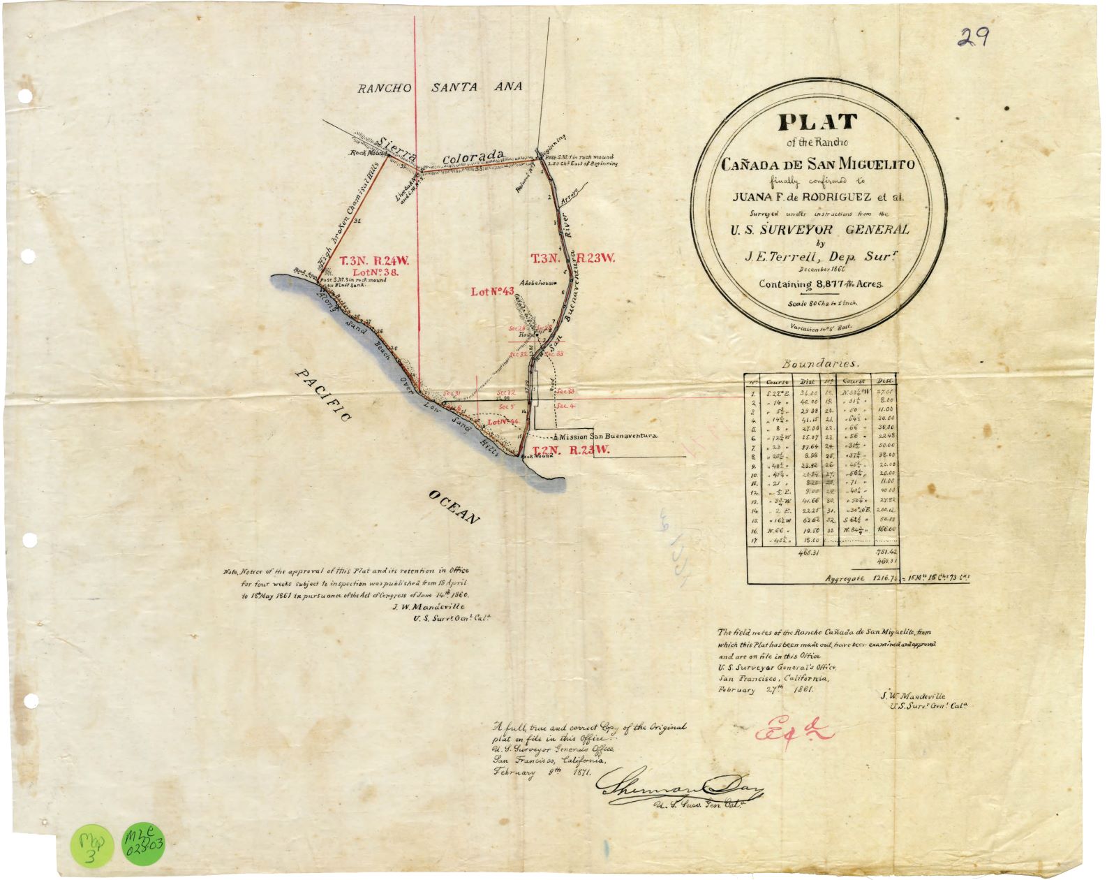
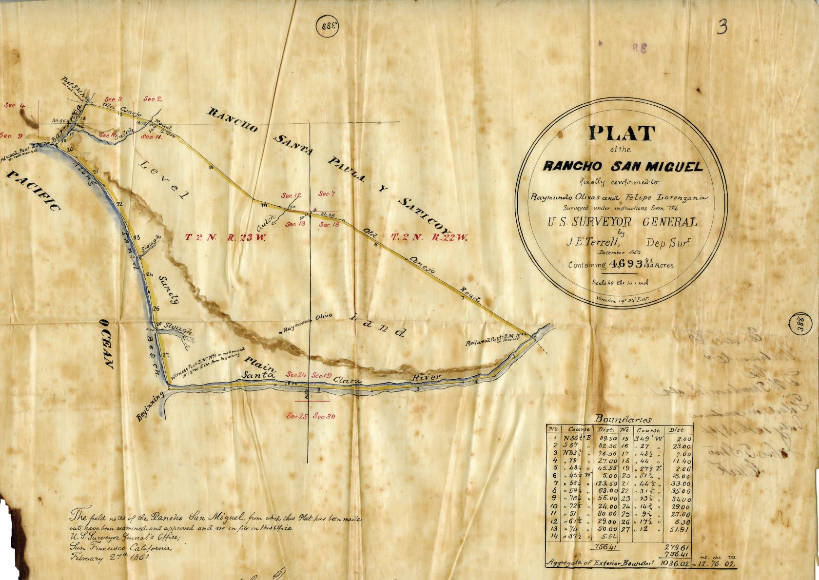
Maps often describe ownership, as shown in a c.1830 diseño (rough, hand drawn map) “Sitio de Ojai”—one of the earliest maps in the collection, or in the historic plat (boundary) maps for Ranchos Simi (1867), San Miguel (1860) and Cañada de San Miguelito (1860), or later in the properties within the Fairview-Moorpark School District of W.E. Alexander’s Historical Atlas of Ventura County (1912).
The subjects covered by maps can be as varied as the 1888 crop map of the Burson Ranch in Bardsdale, which shows what and where crops were planted, or the scene of the crime in the Jesse Howard murder trial of 1877, which occurred in Rocky Creek Canyon in the Sespe.
Maps can also reflect what no longer exists. The vineyard that once served Mission San Buenaventura as well as an “island” in the middle of the Ventura River can both be seen in the 1871 map “Valley of San Buena Ventura.” Maps can even show what was planned but never actually existed, as in the c.1887 map of the town of Sespe, one of many town sites planned by the Pacific Improvement Company.
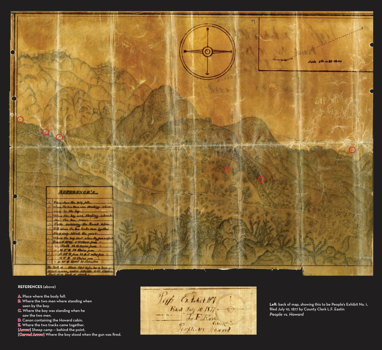
Jesse Jefferson Howard Murder Trial, 1877
Paper on linen, 24″ x 22″
Map No. M4108
In June 1877, cattle rancher Jesse Jefferson Howard shot and killed Basque sheepherder Ydelfonson Urtasun, whom he felt was trespassing on his Rose Valley homestead. Howard was convicted of second-degree murder and housed in the Ventura County Jail. Much to the chagrin of local law enforcement and politicians, Howard escaped and fled to Arizona. He was re-arrested in May 1879, again jailed in Ventura, only to once again mysteriously escape. Howard returned to Arizona where he lived out his days under the assumed name Charles Smith “Bear” Howard.
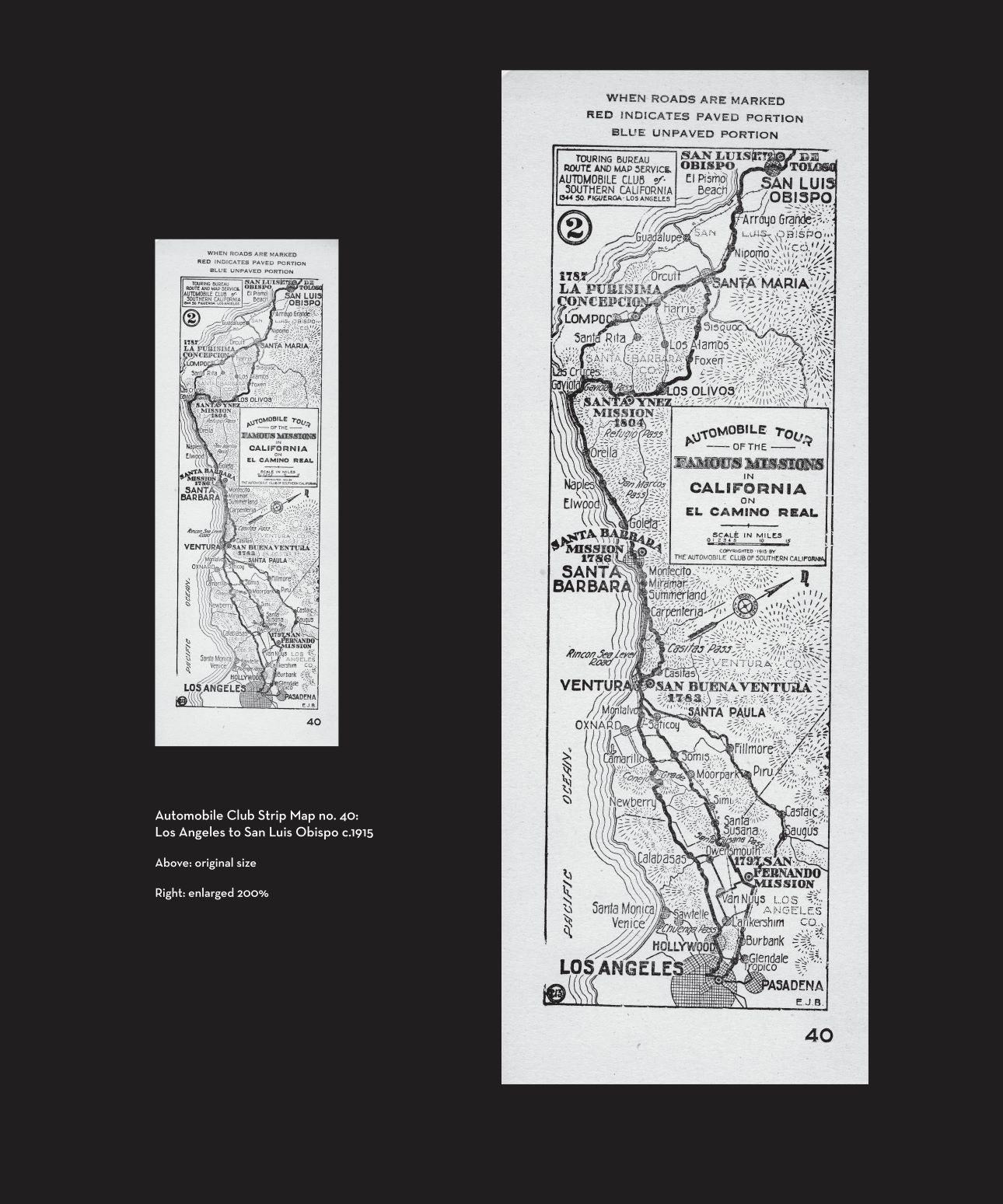
Automobile Club of Southern California
“strip map” 1915
“Famous Missions in California on El Camino Real (Part Two: Los Angeles to San Luis Obispo)” Series no. 40.
The Automobile Club of Southern California produced a series of maps, printed on heavy card stock, from 1911 to 1940. These maps were designed specifically for the motorist and often came in small packet secured by a linen tie (see example in exhibit case). However, if you look at the compass carefully, you will see the initials “A.C.” and “B.C.,” which acknowledges the fact that the “Good Roads Movement,”—a movement to improve the condition of roads across the nation (1870s-1920s)—was a collaboration of automobile clubs and bicycle clubs. This particular map was created by cartographer “E.J.B.,” which stands for Elmer J. Brown, who also designed the bell logo for the Automobile Club.
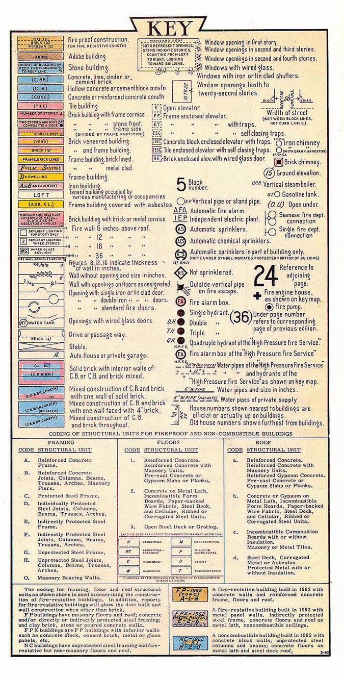
Sanborn Map Fire Insurance Map, 1928, Site Key
The New York-based Sanborn Fire Insurance Company—a publishing company that made maps for insurance underwriters—began making maps for Ventura County in 1886. Among the essential elements of every Sanborn map are 1.) the materials used in a building’s construction, indicated by a color code, 2.) what a building was used for, 3.) location of the closest water main, and 4.) prevailing wind direction. Depending on the year of the map and the complexity of a building, many additional structural features were addressed by a series of symbols. The last volume printed for the City of Ventura occurred in 1928. After that, any additions / changes were printed and glued to the existing page. This volume has been corrected to 1946.
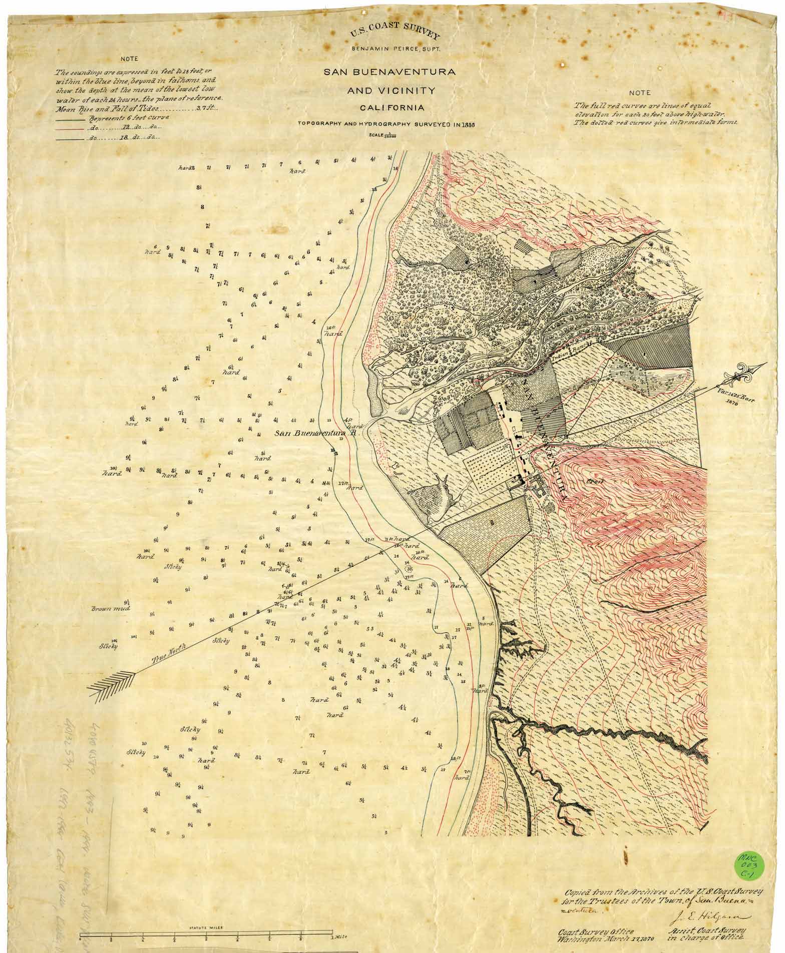
U.S. Coast Survey Map San Buenaventura and Vicinity, 1855.
20″ x 25″.
Map no. MNC 003
Considered to be the nation’s “first scientific agency,”—brought into existence by Thomas Jefferson in 1807—the U.S. Coast Survey (after 1878 known as the U.S. Coast and Geodetic Survey) attracted some of the most talented scientists, artists and naturalists of the time including Louis Agassiz, James McNeill Whistler and even John Muir, who served as a guide and artist for the Great Basin of Nevada and Utah. This map, filed with the Coast Survey office in March 1870, is based on a survey conducted in 1855. It is easily the most requested map in the Research Library (see enlargement of this map containing Mission complex, orchard and garden grounds, including present site of this museum).
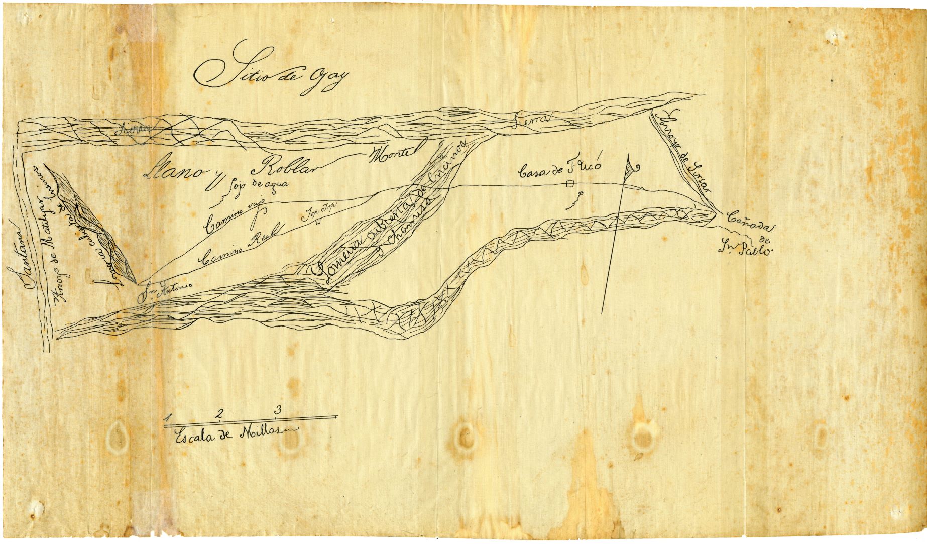
Diseño map, “Sitio de Ojay” c1837
19.75″ x 11.6″
Diseños, or rough-drawn “sketch maps,” were often used in the early to mid-nineteenth century to describe land ownership, especially grazing lands. Such maps usually accompanied formal requests for land grants during the Mexican period (1822-1847) of Alta California. Diseños were also used in California as evidence defending ownership before a Public Land Commission, which had been established in 1851. Without sufficient provenance (ownership history) it is impossible to determine the original purpose of this particular map. We do know, however, that a copy of this map was placed on file with the U.S. District Court (Land Case no. 168), by Fernando Tico, who was originally granted this land by Governor Juan Bautista Alvarado in 1837. Tico successfully defended his ownership of this property before the Land Commission and received his patent in December 1870. Of interest is the location of Tico’s adobe in upper Ojai (Ojay), and an intriguing site named “Top Top” in the lower Ojai Valley.
11″ x 16″
19″ x 15″
12″ x 17″
Plat Maps for Ventura County, 1860-1867
Simply put, a plat map is a map, drawn to scale, showing the divisions of a piece of land.
These three plat maps represent a process overseen by the Surveyor General of the United States, following California statehood (1850), that produced the California Land Act of 1851—which established a three-member Public Land Commission to determine the validity of prior Spanish and Mexican land grants. This process placed the burden on landholders to prove their title. A total of 813 claims came before the Commission, and many cases resulted in protracted litigation. The expense of long court battles required many land holders to sell portions of their property to pay for legal services. A total of 604 claims were eventually confirmed, but some cases were litigated even into the 1940s. In some cases, the original grantee had died before ownership was confirmed; such is the case of Ramon Rodriguez, original grantee of Cañada de San Miguelito (now sometimes known as “Taylor Ranch”), who was murdered on the Rincon while pursuing a thief. He wife, Juana F. de Rodriguez, and their heirs finally received patent (confirmation) to the land in June 1871. Each of these maps was hand drawn on a very fine grade of linen.
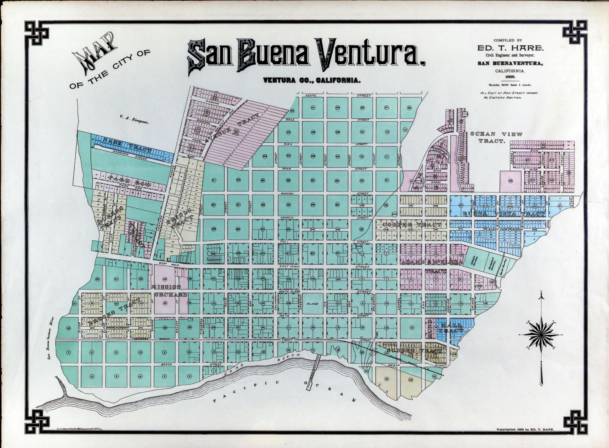
Map of the City of San Buenaventura, 1888
Ed. T. Hare, Civil Engineer and Surveyor. Map No. FD 54
This map shows the extent of the city boundaries in 1888, including the cemetery at the city’s eastern edge, as well as the northern edge of the Ventura Avenue area, which stops at property owned by Volney A. Simpson.
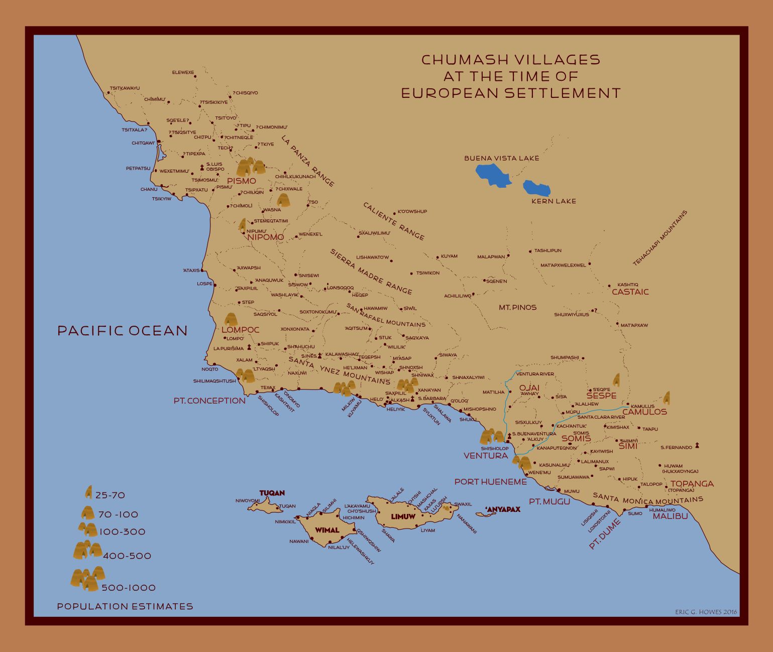
Chumash Village Map
Using several available sources, this map was drawn by designer Eric G. Howes in 2016 for use in the Museum’s Chumash exhibit.
18″ x 24″
9″ x 12″
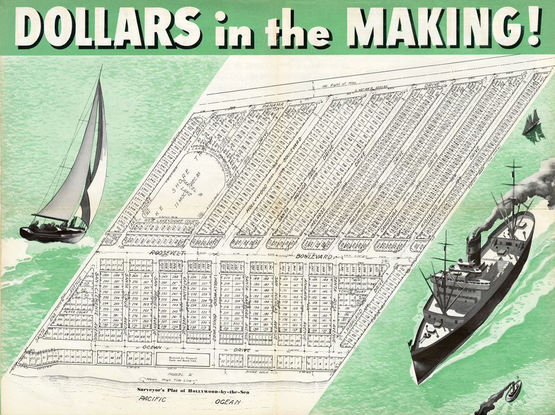
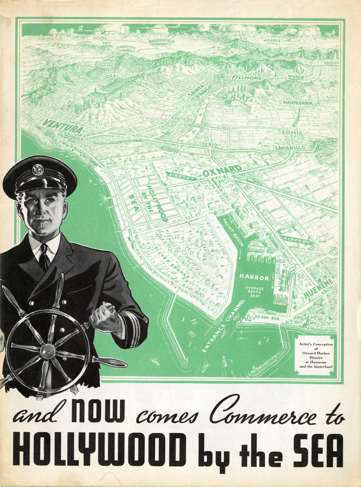
Hollywood-by-the-Sea Promotional Maps
Hollywood-by-the-Sea was part of a larger scheme to develop local waterfront properties in the 1920s.
In 1924, Hollywood Beach was established on a swath of beach that had been part of the Dominic McGrath Ranch. 502 small “cottage-ready” lots, 35 ft. x 65 ft. deep, were listed for sale. This development was conceived by the real estate partnership of William and Frances Lingenbrink and William and Alma Dunn.
In 1925, the Silver Strand was developed by Lingenbrink & Co., who purchased 85 additional acres south of Hollywood Beach and laid out 876 small parcels of land.
In 1926, developer Fred C. Cutting purchased an 80-acre ranch from Leon Lehman, dividing the property into over 100 lots, which he named Hollywood-by-the-Sea.
By 1927, there were 110 beach house in the three seaside communities. This promotional material was printed in 1939.
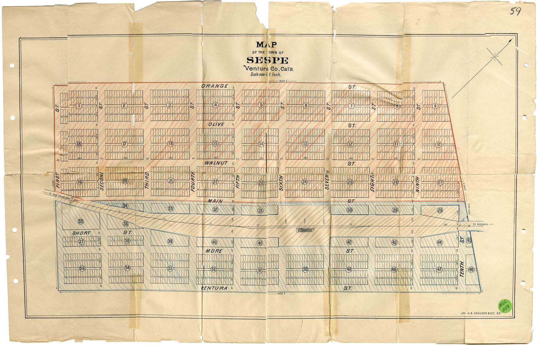
Map of the Town of Sespe [1887]
18″ x 28″
The town of Sespe was a community planned around the route of the Southern Pacific Railroad as it traveled along the Santa Clara River Valley. It was a product of the Pacific Improvement Co., a large holding company established by Collis P. Huntington, Leland Stanford, Mark Hopkins and Charles Crocker (the Southern Pacific “Big Four”) for the purpose of developing railroad-related properties. This town was never built. However, the nearby town of Fillmore, named after J.A. Fillmore, superintendent of the Pacific Division of the Southern Pacific Railroad, was successfully established in 1887.

W.E. Alexander, Historical Atlas of Ventura County, [1912]
Fairview–Moorpark School Districts
24″ x 21.5″
This historical “atlas” is a curious publication in a number of ways. For one, no one is really sure of the publication date; estimates range from 1911-1918, with most historians and librarians arriving at a best-guess of 1912. Like other historical publications of the time, it contains a general history of the area, along with photographs of the homes of prominent citizens and businesses. Nor do we know a great deal about the publisher / compiler beyond the fact that he works for the H.S. Crocker Co., and has done similar books for counties in Iowa, Wisconsin and Minnesota. The text, in fact, was written by E.M. Sheridan, soon to be the curator of the Pioneer Museum in the County Courthouse, precursor to today’s Museum of Ventura County. But Sheridan’s history is only the precursor to what makes this work unique and extremely important. After dividing the entire county by its school districts in a single map, it then devotes the remainder of the book to the owners of property in each school district. As such, it shows not only ownership across an entire region for a particular place in time, it also shows the shape and extent of the ranches and farms. No other source does this. And because of this, Alexander’s historical atlas is gold.