
By Crane S. Miller
In this installment of the Journal Flashback series we present excerpts from an article on the agricultural changes in Simi Valley by Crane S. Miller. In this 1968 article Miller gives an account of the valley’s agricultural history. He is writing in the late 1960s, which would have been on the cusp of Simi Valley’s transformation into a major suburban community in Southern California. Miller states that through the 1960s the population reached 8,000. Imagine how surprised he would be to know that since starting residential development it has grown to over 125,000! (This figure is based on 2019 estimates from the U.S. Census Bureau). We want to thank Research Library volunteer Mary Stewart for extensively fact-checking and editing this copy for clarity. The article is from Volume 13, Issue 4 (August 1968). We hope you enjoy this snapshot of Simi Valley from its sleepy days as an agricultural town.
Lying in the Transverse Ranges of southeastern Ventura County, the Simi region possesses an enviable physical setting of alluvial valley surrounded by picturesque hill country, which coupled with a mild sub-tropical climate has long attracted the attention of man for agricultural settlement. The interaction of man with this natural environment gave rise to a succession of two distinct cultural landscapes in the period 1795 to 1960. During the Hispanic and early American periods of occupancy, 1795 to 1895, a pastoral landscape, one in which cattle and sheep ranching and later dry grain farming were the dominant land-use activities, characterized the region.1 From 1895 to 1960 as more people migrated to the valley and growing markets for high-value agricultural products were brought closer by the railroad, a rural landscape as characterized by intensive farming of subtropical fruit and nut crops came to pervade the scene.
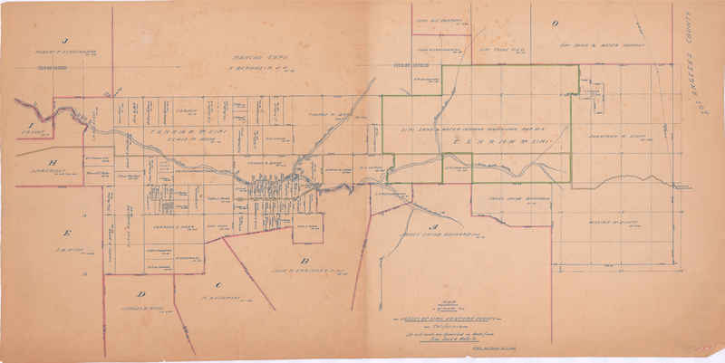
The Spanish and Mexican eras, or what might better be termed “Simi’s rancho days,” introduced a long period of extensive utilization of the valley’s lands, first for the grazing of sheep and later, cattle. It followed that a pastoral landscape came to pervade the Simi region and persist even long after California was lost by Mexico to the United States. Hispanic occupancy of the Simi Valley spanned a period of some seven decades, from about 1795 until midway into the 1860s. During this period ownership and control of the valley and its environs was held by two Spanish families, first the Picos and later the de la Guerras. Thus, the earliest extensive land use of the Simi region depended almost entirely upon the activities of these two families. The original grantees (the Picos) did little to develop their empire, and during the 1810-1822 war in which Mexico won independence from Spain their title to the rancho lands may even have lapsed. But to their more imaginative successor, Don José de la Guerra y Noriega, the verdant bottom lands and hillsides of the Rancho Simi became the basis for a vast sheep and cattle-raising enterprise. Early in his term as governor of Alta California, Diego de Borica granted to Patricio, Miguel and Francisco Javier Pico the Rancho San José de Nuestra Señora de Altagracia y Simí. The 1795 grant, as later confirmed by a United States survey, contained an area of 113,009 acres. Rancho Simi proved to be one of the largest grants in California. Of the 19 Hispanic grants and concessions issued in Ventura County, only two were bestowed by Spain: Simi and Conejo. The rest were granted by Mexico.
The earliest detailed description of the Simi Valley was written in 1797 by Father Vicente de Santa María from Mission San Buenaventura. The rather dismal report was based on a reconnaissance of the valley in August 1795 by Father Santa María and ultimately precluded the Simi from consideration as a new mission site, and read as follows: “In the middle of the forenoon, going toward the east, little by little we reached a valley which is called Simi. In the middle of the valley we came upon a small pool of water in a dry arroyo which crosses the valley halfway. In the afternoon the ensign, sergeant, two soldiers and I went to reconnoiter a place, which, said José Antonio Lugo, claimed to have seen, and which, he said, had water and land. After examining everything, we found the water to be not too abundant, the valley very narrow and dismal, and consequently unserviceable.”
Extensive utilization of Simi Valley land was initiated with the importation of sheep into the region early in the 19th century. The raising of sheep was an undertaking conducted jointly by the Pico brothers and the fathers of the San Fernando Mission. Mission San Fernando Rey de España was built in 1797 and Simi was included in its jurisdiction. The extent of sheep raising in the early days of Rancho Simi (that is, in terms of the number of heads and income derived from the sale of wool) is unknown. The operation was probably never of great significance, for in February of 1816 Governor Sola received word from Mission San Fernando that there was no place for the mission sheep to feed now that Patricio Pico had notified the padres to remove them from his land. And in 1819 the last of the sheep had been driven from the Simi by the Picos.
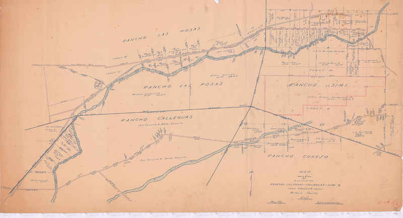
The Simi region did not see the full blossoming of its pastoral days until late in the Mexican period when it became the domain of Don José de la Guerra y Noriega. Although de la Guerra did not acquire Rancho Simi until 1842, he was not new to the California scene. A native of Spain, de la Guerra first came to California in August 1801 at the age of 22. His early years in California were spent as an officer in the service of the Spanish army. It was while he was commander of the presidio at Santa Barbara (from 1815) that his name was first linked with the Simi: in 1818 Father Señan corresponded with de la Guerra regarding the dispatch of soldiers to the Simi during the Bouchard2 threat. De la Guerra’s first land-buying venture came with his purchase of a portion of the 48,671-acre Rancho El Conejo in 1822. In 1827 he was elected to the post of diputado3 to the Mexican government, but he failed to take the seat and subsequently returned from Mexico City in 1829 to devote his energies entirely to ranching. De la Guerra’s next purchase of land was of Rancho Simi, which was later followed by his acquisition of the 26,623-acre Rancho Las Posas, bringing his total holdings in the Ventura region to nearly 200,000 acres. The sum paid to the Pico brothers for the 113,009-acre Rancho Simi included $800 in cash, $219 in goods and a promise by Don José to pay a debt of $2,000 owed by one of the Picos to the Mission San Gabriel. Governor [Juan Bautista Valentín] Alvarado [y Vallejo] officially transferred the grant to de la Guerra in April of 1842 and Governor Pío Pico validated it in 1845. Once California fell into American hands, de la Guerra wasted little time in validating his title to Rancho Simi, lest his holdings be thrown open to public settlement. Under the provisions of the Treaty of Guadalupe Hidalgo, which ended the war between Mexico and the United States and ceded California [as well as much of the Southwest] to the United States, the United States was bound to respect and protect all property rights under certain conditions. De la Guerra filed his deed with the General Land Office of the United States, and in 1854 he received a decree of confirmation to the entire Rancho Simi.

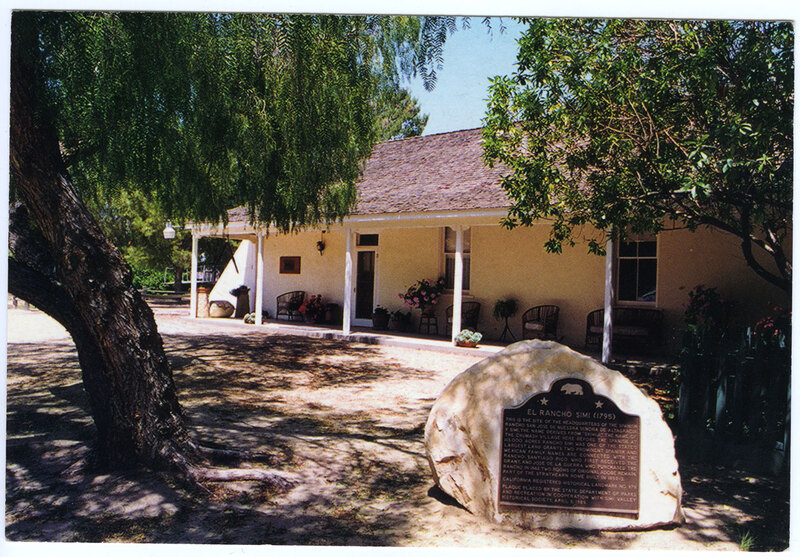
Although agriculture during the forties and fifties was based on a pastoral economy, some gains were made in efforts to cultivate the soil, notably in the eastern end of the valley floor at Rancho Simi and in Tapo Canyon. At Rancho Simi the gardens and orchards originally planted by the Picos were enlarged to an area of some 40 acres, the most notable additions being a large vineyard of mission-variety grapes and several olive trees. In 1858 a major portion of the adobe dwelling at Rancho Simi was again destroyed by Indians,4 causing the de la Guerra family to move to Tapo Canyon where a large adobe structure had been built several years earlier. Another consideration in relocating to Tapo Canyon was the presence of a dependable water supply from Tapo Creek, which was considered to be a perennial stream in the 19th century. Known as Tapo Alta, this now became the headquarters for the de la Guerra operations in the Simi region. In the upper portion of Tapo Canyon adjacent to the adobe, the de la Guerras planted a large flower garden and orchards of white olive, fig, orange, apple, and pear trees. Farther to the south, near the mouth of Tapo Canyon, the de la Guerras had earlier in the 1850s planted several acres of mission-variety grapes. A winery was later established, and by the end of the decade the wines and brandies of the Tapo had become renowned throughout the state for their excellence. Heretofore, the de la Guerras had maintained a townhouse in Santa Barbara, only visiting the Simi to review the cattle or to be present on festive occasions. For example, sheep shearing time in the spring and grape harvesting and wine-making time in the fall were events which were often accompanied by elaborate fiestas. However, with their move to Tapo Alta, the rancho now became their main residence.
In February of 1858 José de la Guerra y Noriega died, bequeathing Rancho Simi to his nine children (his wife had died in 1843). The rancho continued to prosper under the guidance of his sons (Antonio, Francisco, Miguel and Pablo de la Guerra) until 1863-64 when an unprecedented drought struck a near deathblow to the California cattle industry. In Santa Barbara County, which present-day Ventura County was then a part of, out of some 200,000 head of cattle listed on the tax rolls, 190,000 died. Rancho Simi was especially hard hit, losing by death or forced sale almost its entire stock of cattle and a great many of its sheep. Early in 1862 the San Francisco market was swamped by thousands of head of cattle from debt-ridden owners of Santa Barbara County; the de la Guerra family alone disposed of 4,000 head. Although sheep ranching would later be revived by the Americans, cattle raising in the Simi region would never again reach the proportions it had attained under de la Guerra.
During the sixties and seventies, ownership of the vast Rancho Simi passed through the hands of several people with little thought of what the property would someday be worth. The loss of its cattle accompanied by a depression forced the de la Guerra family to execute a mortgage covering the rancho and other property for $25,000 in favor of Isaac Cook in 1861. A year later Cook commenced action to foreclose his mortgage and by October of 1864 he acquired a valid title by virtue of a sheriff’s deed to all of Rancho Simi. A few weeks later Cook conveyed the entire property to Levi Parsons, and he in turn to John Church and John Wyeth. Meanwhile, the de la Guerras had executed an oil lease to Albert Packard, who eventually passed the mineral rights on to Eugene Sullivan.
In 1865 Thomas Bard, representing Thomas Scott of the Philadelphia and California Petroleum Company, came on the scene and immediately moved to settle the de la Guerra litigation. But it was not until September of 1870 that a final settlement was reached, with Rancho Simi coming under the sole control of the Philadelphia and California Petroleum Company. It is said that Scott, largely through the efforts of Thomas Bard, acquired all of his Ventura region holdings, including Rancho Simi, at an average cost of 65 cents an acre. In settlement of the litigation the de la Guerras were allowed to retain 14,000 acres in Tapo Canyon and were also given grazing privileges for their sheep in Simi Valley. But financial troubles continued to plague the family, resulting in the sale of the canyon property to Thomas Bard in 1879. The boundaries of Rancho Tapo were later fixed, and the 14,000-acre property eventually sold to A. Bernheim for less than $10,000.5
Although Packard, Sullivan, Bard and others found seepages of brea (tar) in the foothills of the Santa Susana Mountains, the actual discovery of oil in the Simi region did not occur until the turn of the century. Oil was found elsewhere in the Ventura region, and the prospect that it would someday be found in the Simi induced Thomas Scott to hold the rancho lands until his death in 1881.
With the de la Guerra litigation settled (1870) and little likelihood that oil would be found, the Philadelphia and California Petroleum Company authorized Thomas Bard to lease the valley floor for agricultural purposes. In 1871 Bard leased 12,000 acres in the eastern end of the valley to Charles Hoar, who became the Simi’s first American farmer. Hoar was to pay one-fifth of any crops he raised as rent. A short time later, Hoar entered into partnership with A. W. Brown and a man named Bates. The three men leased all of the valley floor, utilizing the land solely for the raising of sheep. By 1880 there were 13,000 head of sheep in the partnership’s herds.
Thus the valley landscape of the early eighties was much as Thompson and West had observed and described it with “forests of live oak at the upper end and clothed with fields of wheat far down the wide plains; here and there, though far apart, stand the quaint farmhouses of this region.” They also gave an account of potential land use in the greater 98,000-acre Rancho Simi area of 11,000 acres for farming, 67,000 acres for grazing and 20,000 acres of “no use except for bee pasturage.” On the last item it is noteworthy that the ranchers often complained that the “only one who ever made any money” in the valley was an apiarist named Samuel Easley whose bees in one year produced 120,000 pounds of white sage honey, which he transported to Port Hueneme and sold for 5 cents per pound.
The arrival of the Southern Pacific Railroad in 1876 increased immigration to southern California; when the Santa Fe came in 1885 and the ensuing rate war reduced the fare from Kansas City to Los Angeles to as low as one dollar, tourists and prospective settlers began swarming into the Southland. Out of this influx was born the land boom of the 1880s in southern California. It soon spread to the Simi Valley and initially took form with the creation of the Simi Land and Water Company.
In 1881 Thomas Scott died, leaving Thomas Bard to settle his affairs in Ventura County. … Bard next moved to invest his own money in Simi land. In liquidating the estate of Thomas Scott and the Petroleum Company, the Simi and Las Posas Syndicate was formed with Bard’s initial investment amounting to one-fifth ($30,000) of the syndicate’s assets: 99,000 acres in the Simi region and 25,000 acres in the Las Posas region, at a total book value of $62,500. In the opening quarter of 1887 Bard increased his syndicate holdings by buying out some of the eastern owners; later that year Bard sold part of his interest in the syndicate to Daniel McFarland, but still retained three-tenths of the syndicate’s assets. It is noteworthy that the Los Angeles Tribune hailed the sale of the Rancho Simi in 1887 to the syndicate as the “largest individual transaction … consummated in this county since the boom began.” In the summer of 1887 Bard, McFarland and five others formed the Simi Land and Water Company to subdivide and sell the syndicate’s lands; the company was capitalized at $650,000, issuing 6,500 shares of stock at a par value of $100 each. Bard’s three-tenths interest in the syndicate became 1,884 shares in the Simi Land and Water Company, of which McFarland sold more than 1,100 shares during the flush months of 1887 for a return to Bard of $113,000, thus netting a tidy profit on his total investment in the original syndicate. This proved to be the most lucrative real estate transaction in the career of Thomas Bard.
As for the development activities of the Simi Land and Water Company, they began in earnest early in 1888 with the construction of an imposing three-story hotel on a knoll in the eastern part of the valley and subdivision of valley lands for sale at $10-$100 an acre, prices which the Los Angeles Express noted were “less than half the prices asked anywhere else in Southern California for lands of the same quality.” When the company launched an advertising campaign in Los Angeles, Chicago and Cincinnati newspapers, the first to respond, late in 1888, was a group of eight Chicago doctors who formed the California Mutual Benefit Colony of Chicago. They agreed to join the Simi Land and Water Company in buying two square miles (sections 8 and 9) in the western end of the valley to erect a health resort and a town to be known as Simiopolis. But Simiopolis never became a reality.
Although 12 ready-cut houses were shipped into the valley by the colony, the land boom had begun to wane and only a few of the purchasers who had originally signed with the colony ever made it to California from the east. In 1891 the colony was dissolved and the Simi Land and Water Company repossessed the land; however, those colonists who had invested money and expressed a desire to remain in the Simi were allowed to keep their houses. From 1888 to 1890 some 20 settlers not connected with the colony, who had also seen the newspaper advertisements, came to the valley.
The “Boom of the Eighties” had figuratively put Simi on the map, but when the boom began to decline, so did the interest in this small, isolated valley; the anticipated flood of immigrants had not materialized and only 38 votes were cast at the first election held in the valley in 1890. Eventually most of the Simi Land and Water Company’s stockholders exchanged their shares for valley and hillside land. For his remaining shares Thomas Bard had acquired 852 acres of valley land, which he pooled with the acreage owned by his family and friends for renewed operations in barley, wheat, and sheep. Bard never again figured prominently in valley affairs, but the Berylwood Investment Company (formed by the Bard family partially as a result of the aforementioned pooling of resources) retained their valuable acreage in the center of the valley until the middle of the present decade.
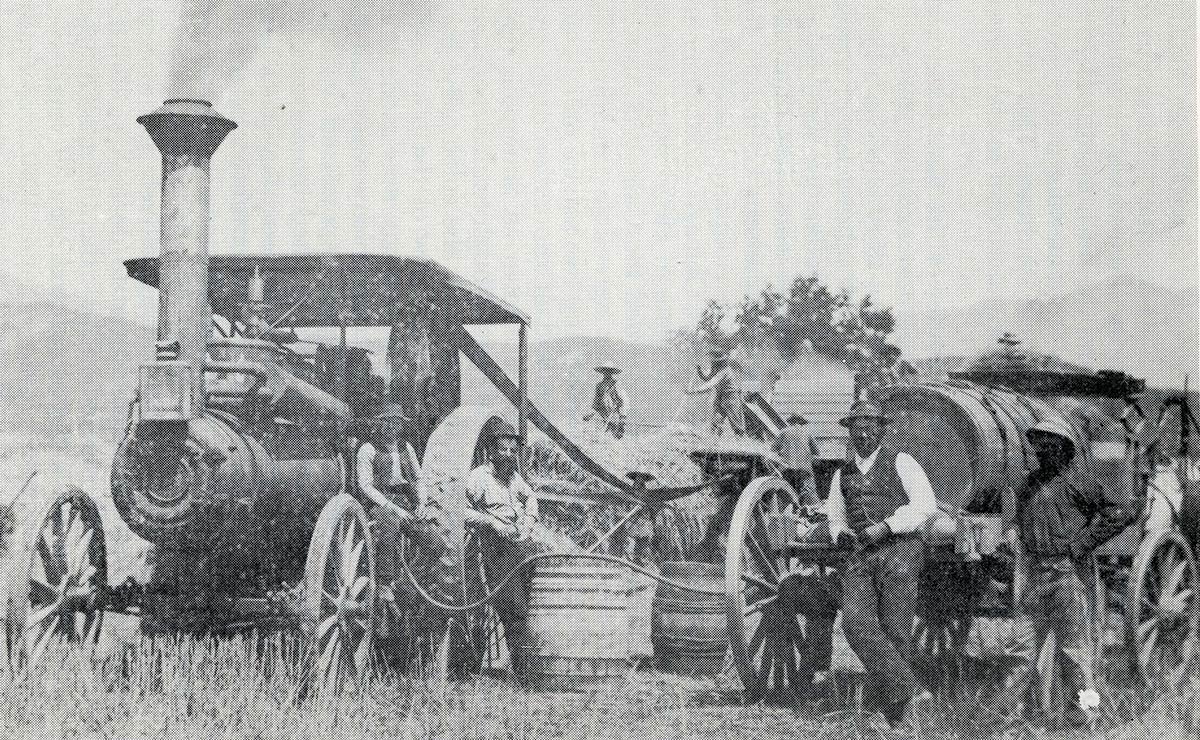
Despite the realty upheaval and the beginning of subdivision, valley farmers increased their acreage in forage grasses, wheat and especially barley. The year 1887 saw the Simi’s first major crop of barley harvested, and by the end of the decade most of the valley floor was devoted to dry farming – the only notable exception being the woodland-grassland area of 2,000 acres at the eastern end of the valley, which was retained as sheep pasturage.
Barley was an annual crop, usually being sown in late fall before the first heavy rains and harvested in mid-summer. For a short time following the harvest, the sheep in the region were allowed to graze on the stubble. … From 1887 to 1895 annual production of barley in the Simi averaged 100,000 sacks or about one-third of that produced in Ventura County as a whole.
After 1893 barley acreage and production steadily declined in Simi Valley, as well as in Ventura County as a whole. This could be ascribed as much to competition from the grain belt counties of the San Joaquin Valley as to the desire of increasing numbers of small landowners to irrigate the land and raise specialty crops. Perhaps the new arrivals had read of the lush gardens and orchards of the de la Guerra era at Rancho Simi or heard of the exploits of the water-witch (Moroni Stones) whose successes in locating artesian and subartesian wells in the valley and Tapo Alta had become legendary. Or it was simply a matter of economics: since the railroads from the East were pushing ever-closer to the valley, there seemed every likelihood that vast new markets for high-value agricultural products would soon be available and that seasonal labor to harvest and process the crops would be more readily obtainable. In any case, the “new agriculturists” of the mid-nineties inaugurated the period of more intensive land use which has continued to the present decade.
The introduction of deciduous fruits in the mid-nineties marked the beginning of intensive farming in the Simi Valley. It was found that prunes and apricots did well in the southern portion of the valley plain; but there was only limited expansion of acreage or gain in production until after the turn of the century, when irrigation was instituted on a larger scale and the Southern Pacific Railroad came to the Simi. These events served to spur agricultural development for apricots, which, when sun dried and shipped mostly to western Europe, became the mainstay of the Simi economy.
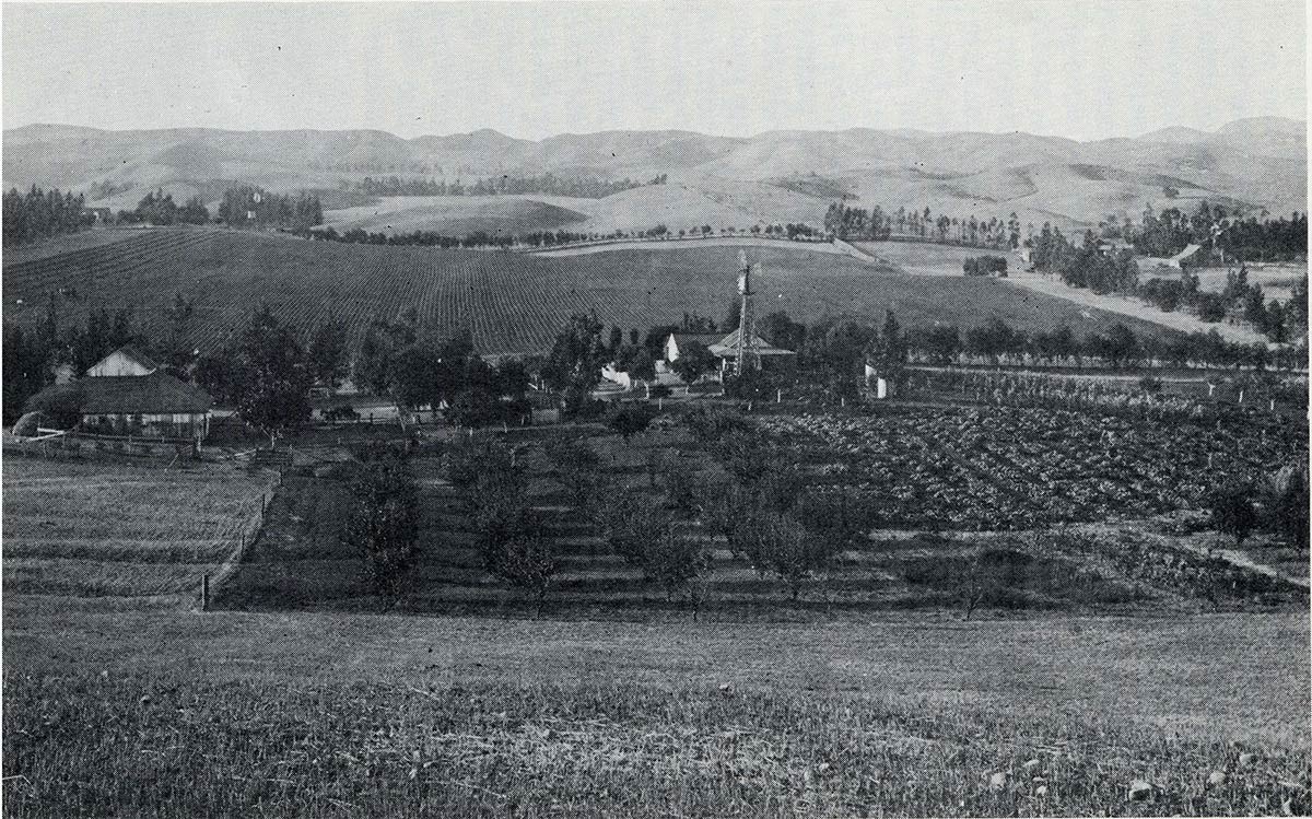
By 1925 four separate communities had come into being, and population in the valley was nearing one thousand. World War I seriously curtailed exports of dried fruits, thus temporarily halting further expansion of deciduous fruit acreage. However, during the war years farmers experimented with other tree crops including various varieties of walnuts and oranges, finding that conditions of soil, air, drainage, and water supply were nearly ideal, especially in the higher, north-central section of the alluvial piedmont. This area of the valley known as the Tapo district became one of California’s important producers of Navel, and later Valencia oranges, and, lemons, gaining a reputation that has endured from the early twenties to the present day. There were plantings of walnuts and citrus in other parts of the valley, with the Valencia orange eventually becoming the Simi’s most valuable commodity.
The centering of the citrus industry below the mouth of Tapo Canyon also affected the texture of settlement with a steady shift of the core of population during the thirties and forties from the southern half of the valley to the north-central portion. In the 1950s, despite the imminence of urbanization (the population increased from 3,000 in 1950 to over 8,000 by the end of the decade) intensive agriculture attained its zenith with almost 6,000 acres under irrigation; and the valley accounted for nearly 3% of southern California’s annual production of Valencia oranges.
…
Despite below average precipitation that had extended for several years since the “last wet winter” of 1889-1890, growers relied primarily on rainfall to meet the moisture requirements of their crops. To help alleviate the problems of a prolonged drought, orchardists planted more heavily to the early ripening apricot than to the prune; because it was harvested in early July, the apricot was less likely to require irrigation than the prune, which was not picked until mid-September. Nevertheless, it was apparent to some growers that the meager rainfall of recent years would have to be supplemented by groundwater, even for apricots. … Irrigation not only tended to mitigate the ill effects of over a decade of relatively dry years, but also to increase crop production. Its benefits became evident to increasing numbers of growers, resulting in the slow spread of irrigation systems throughout the tree crop areas of the southern plain. By 1912, 500 acres were under irrigation. Increased pumping lowered the water table, but a return to a period of years with normal rainfall kept groundwater reserves at safe levels. Irrigation agriculture was rapidly becoming the basis of the valley’s economy and occurrence of another protracted drought would seriously jeopardize the growth of that industry.
Although the introduction of irrigation provided the basis for intensive farming in the Simi, it was the coming of the railroad that first exposed the valley to rapid expansion of its agricultural potential. For over a century since the advent of the Spanish in 1795, isolation had imposed an effective restraint on the Simi’s development. The Southern Pacific Railroad broke that barrier by linking the valley with transcontinental rail routes; Simi farmers could now share in the trade with eastern markets that had helped make agriculture the mainstay of the California economy. Due to a preference for canned and fresh fruit in the United States, Simi dried apricots found their main outlets in western Europe, particularly Germany; the key factor in this trade was rail linkage with the ports of Hueneme, San Pedro, San Francisco, and New York. Except for a brief hiatus during World War I, export of dried apricots in the teens and early twenties probably amounted to upward of 500 tons annually, with growers receiving from 5-10 cents per pound.
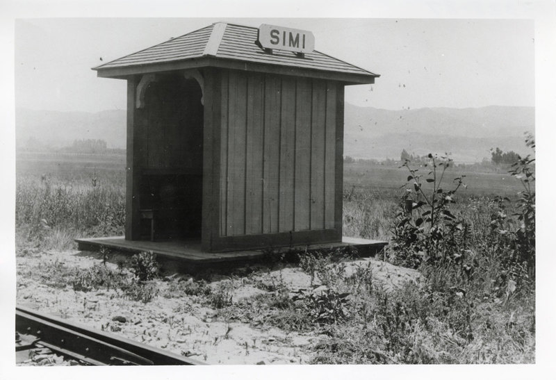
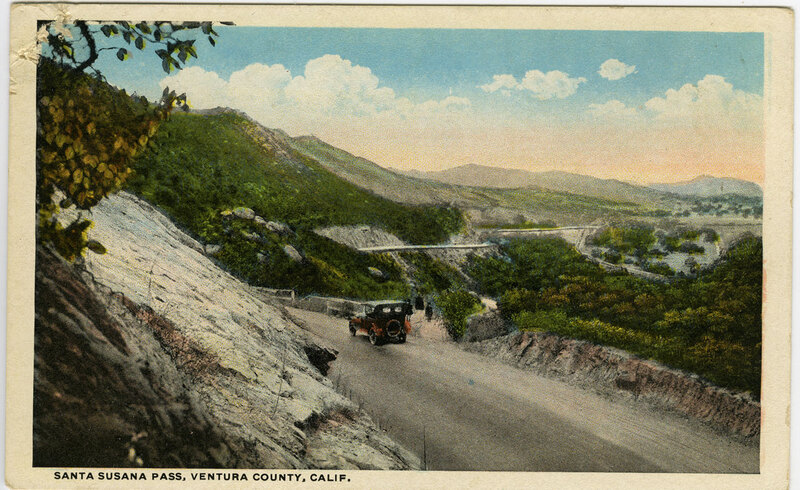
Construction of the railroad through the Simi Valley, which remained the last gap in the Southern Pacific’s main coastal line from Los Angeles to San Francisco, started in 1900 and was completed in 1904. The highlight of the project was the building of a 7,369-foot-long tunnel under Santa Susana Pass at a cost of $1 million. It was with the economy in mind that the Southern Pacific Company located its main depot at Santa Susana. Here they were furnished land for a station and section house, whereas elsewhere along the line that parallels Los Angeles Avenue throughout most of its course landowners were not given to such generosity. Another reason for locating some three miles east of the center of agriculture at that time was the presence of a long stretch of relatively level land at Santa Susana, which facilitated the starting of trains.
In 1900 the major part of the population of less than 200 was located at the site of the old Mutual Benefit Colony, which later became the town of Simi, and in the adjoining orchard region to the southeast. The rectangular road pattern, of which Royal Avenue and Los Angeles Avenue were the main segments, was developed only in the south-central portion of the valley floor and at Simi.
A quarter of a century later the population had increased nearly five-fold and had become concentrated in four distinct communities, all located in the southern half of the valley: Simi, Santa Susana, Santa Susana Knolls and Community Center. Settlement in the lower part of the valley was largely the result of the Southern Pacific’s locating its main line there. The main roads had been paved and the general street pattern had become somewhat more elaborate on the valley floor. Roads to the tributary canyons were improved, but, except for Tapo Canyon and Meier Canyon, agricultural development and settlement remained largely absent from the hill country.
From 1930 to 1950 the population tripled to 3,000, with the greater part of it becoming concentrated in the central and north-central plain, in response to enlargement of the Tapo District as the valley’s main area of citriculture. Development of a partial grid-like street pattern, due largely to the alignment of streets parallel to long rows of eucalyptus windbreaks, also became most pronounced in this region of the valley.
During the fifties the population increased to over 8,000, and work was started on the first extensive housing tracts. Yet, with an economy still based almost entirely upon agriculture,
a typically rural southern Californian landscape pervaded the Simi Valley until the end of the decade. Small landholdings, rows of eucalyptus windbreaks, orange groves, walnut orchards, small areas of truck farming and grain farming, an occasional poultry or rabbit farm, numerous paved roads and clusters of dwellings sometimes half hidden by trees and shrubs were the essential elements of the scene.
By the early 1930s approximately one-third, or 6,000 acres, of the valley floor was under irrigation. Unlike the Tapo district, the trend in other parts of the valley in ensuing years was toward a greater diversity in crop types; there was one notable exception to this trend, the supplantation of apricots and other deciduous fruit trees by citrus and walnut trees. In 1932 there were 583 acres in deciduous fruits; by 1950 this acreage had declined to only 21 acres.
Agricultural development in the Simi tended to level off during the fifties, not only because urbanization was on the horizon, but also because there was not sufficient water for further expansion of irrigated acreage. In the period 1927-1951 there was an average annual reduction in groundwater reserves of 1,812 acre-feet, which was due to a variety of conditions: the introduction and expansion of irrigated crops, the trend to implantation of crops with relatively high moisture requirements, the increase in urban requirements, the
low ratio of watershed area to valley floor area, the drought period of 1945-1950, poor irrigation methods, and the lack of adequate water conservation methods. Before the importation of Colorado River water to all parts of the valley in 1963, the availability of water had been the prime determinant of land value. For example, irrigated land in the Tapo district was valued at $2,500 to $3,500 an acre in the early 1950s, whereas non-irrigated land on the eastern plain averaged only $1,300 an acre. As a matter for conjecture, had the importation of water come just a decade earlier before the beginnings of urban encroachment, agricultural acreage and production in the Simi Valley might well have been considerably greater than what they were.
- The author does not address the Indigenous history of the area. We encourage readers interested in the history of the Chumash to read any of these books, available through the Ventura County Library system, or to check out the Chumash Indian Museum’s website.
- Hippolyte Bouchard was a privateer who raided the California coast.
- A diputado is a representative in a legal chamber similar to a congressperson.
- This wording reflects the original author’s terminology, and the museum does not use this word in current publications, posts, or descriptions.
- For more on the topic and how many Mexican families lost their titles to land following an influx of American settlers see the following PDF, which is a good starting point for further reading.